

When people think of Appalachia, ports are not often the first things that come to mind. On the contrary, as a mountainous, landlocked region at least 50 miles from any coast, Appalachia is often seen as a “stranger to blue water.”
In reality, though, water has been essential in creating modern Appalachia. Whether one is discussing the settlement and industrialization of the Ohio Valley or international coal exports, Appalachia’s development has been bound up in the regional and global connections permitted by waterborne commerce.
However, these connections have proved a double-edged sword. While facilitating economic development, waterborne trade has also contributed to the region’s exploitation. In many ways, Appalachia’s coal-dependent economy relies on the cheap transportation provided by its rivers. Moreover, although once supporting a robust industrial base, these rivers are now littered with the toxic legacies of industry, threatening regional health.
For both good and ill, ports made Appalachia what it is today.

The Ohio River basin has played a major role in Appalachia’s history for millennia, with archaeological evidence indicating the river and its tributaries were central to pre-colonial Native American societies. When Europeans arrived, they realized the Ohio’s importance—British and French competition over the Ohio Valley contributed to the Seven Years’ War, and much of the early United States’ foreign policy was concerned with expelling the area’s Native Americans.
Following the consolidation of US control in the 1790s, the Ohio became a highway for European colonizers heading west. Settlers journeyed down the Ohio from Pittsburgh, founding or joining river towns like Wheeling, Marietta, Parkersburg, and the major ports of Cincinnati and Louisville further west. This was the era of the keelboat, represented in folklore by freewheeling boatmen transporting cargo up and down the Ohio and Mississippi.
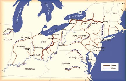
Nevertheless, it was not long before larger forces started to tame the river. Steamboats came into widespread use by the 1820s, and both Ohio and Pennsylvania constructed canal systems to link the Ohio River to Lake Erie and the Atlantic Ocean, permitting the bulk shipment of goods internationally for the first time.
Not all infrastructure projects were improvements though. After the National Road reached Wheeling in 1818, the city became a major depot for shipping slaves down the Ohio, and the river became a “slave-trading highway” until the Civil War.
However, it wasn’t until after the Civil War that two major infrastructure developments—the coming of the railroads and the canalization of the Ohio River—fundamentally changed Appalachia’s relationship with the wider world.
The first railroad arrived in the region a few years prior to the Civil War, with the B&O Railroad linking Wheeling and Parkersburg to Baltimore in the 1850s. However, a more momentous change occurred with the arrival of the Chesapeake and Ohio (C&O) Railroad in the 1870s, linking southern West Virginia and the Ohio River to the port of Newport News, Virginia.
That connection initiated several changes, the effects of which can be felt in Appalachia today. The first and most obvious was the opening of the southern West Virginia coalfields. With railroads, previously inaccessible coal became commercially viable, contributing to the development of southern West Virginia around Charleston, which had until that point lagged behind northern areas of the state.
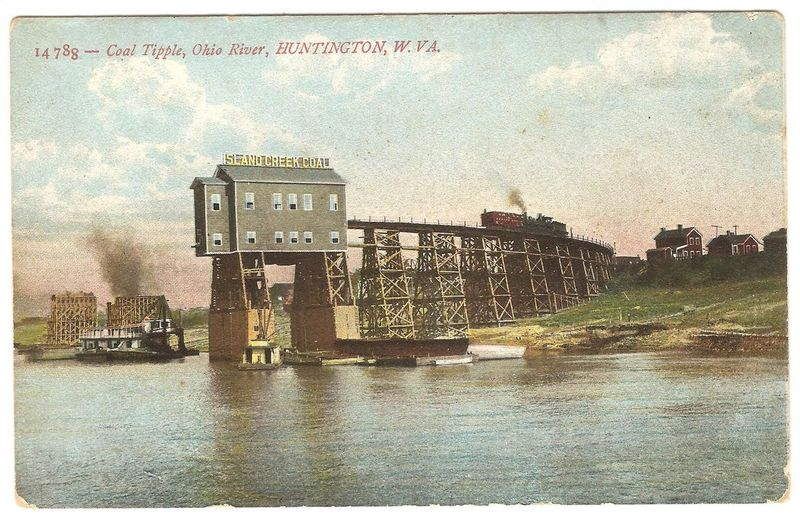
Less remarked upon is the shift in Ohio River commerce caused by the C&O’s establishment of Huntington, West Virginia, which was founded to be the railroad’s transshipment port on the Ohio. Starting from almost nothing in 1871, Huntington port was handling hundreds of thousands of tons of coal per year by the early 1900s, and the city grew to become West Virginia’s largest by 1930, anchoring a heavily industrialized area that stretched into Kentucky and Ohio.
Even today, amid significant decline due to a reduction in coal shipments, Huntington remains the busiest Ohio River port between Pittsburgh and Cincinnati, shipping 36.7 million tons of goods in 2019, 55 percent of which consisted of coal.
On a global scale though, the railroads’ most profound effect was the linking of central Appalachia to ports on the Atlantic coast, through which the region’s coal was exported worldwide.
Due to these rail connections, the histories of several Atlantic port cities, including Baltimore and Norfolk, are intimately linked with the central coalfields. Newport News, Virginia’s fifth-largest city and a major part of the third-largest port on the East Coast, was largely developed by the C&O Railroad to ship Appalachian coal to cities in the US Northeast, with Newport News and nearby Norfolk boasting massive coal piers to load ships.
These coastal connections have helped Appalachian coal take on a more international orientation compared to other regions. While Wyoming, the top US coal-producing state, exported less than 1 percent of its coal internationally in 2018, West Virginia, the #2 producer, exported 41 percent of its coal to other countries, with other Appalachian states having substantial international markets. In 2018, the Baltimore and Norfolk customs districts (which includes Newport News) together accounted for roughly 53 percent of all US coal exports, a legacy of their 19th-century connections.

Although it took place later than the coming of the railroad, and over a much longer period, the canalization of the Ohio River basin brought even more fundamental changes to Appalachia, if only because it permanently altered the region’s environment.
The Ohio, Kanawha, and Monongahela Rivers today are not natural rivers. Natural rivers are inconvenient to industry. They have poorly placed islands and inconsistent depths. Perhaps most annoyingly, their water levels vary erratically. The Ohio River once dried up so much during the summer that people could walk to islands in the middle of the stream. At other times, it unleashed torrential floods that destroyed entire towns.
Canalization aims to change that. It involves removing islands and dredging the riverbed to create a consistent channel depth—at least 9 feet deep for the Ohio—as well as building a series of locks and dams to normalize water levels, such that the river becomes more of a series of interconnected pools than a river.
Undertaken by the US Army Corps of Engineers, the canalization of the Ohio basin picked up steam in the late 19th century. The first Ohio lock and dam was completed below Pittsburgh in 1885, and the entire river was gradually canalized until 1929. Some of the Ohio’s tributaries saw faster progress, with the Monongahela being partially canalized by the 1840s and the Kanawha becoming America’s first fully canalized river in 1898. Today, the US Army Corps of Engineers operates 21 locks and dams along the Ohio River to control water levels.

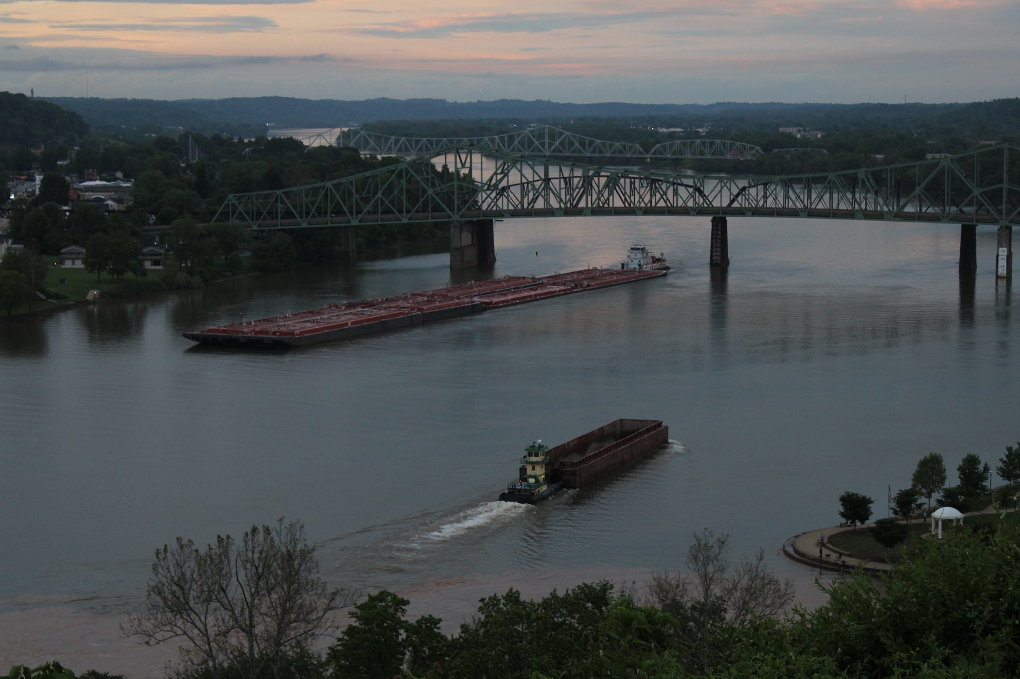
Once complete, canalization allowed more and larger barges to navigate the Ohio year-round, permitting a level of access to Appalachia’s coal unthinkable even with railroads, thanks to lower costs. Though slower, it is much cheaper to ship bulk goods like coal by water than other forms of transportation. Even today, a 15-barge towboat can carry the same amount as 1,050 trucks, and it can carry a ton of cargo 647 miles per gallon of fuel, compared to 477 miles for trains and 145 miles for trucks.
Canalization allowed coal producers to exploit this efficiency, with coal production in the Kanawha Valley increasing drastically after the Kanawha River was canalized, jumping from 166,000 tons in 1875 to over a million in 1898. The paths canalization cleared for shipping in the Ohio basin remain in use today. Of the 149 million tons of coal produced in Appalachian states touching the Ohio in 2016, 42 percent was transported by barge.
Canalization didn’t just affect coal though. It also laid the groundwork for the massive industrialization of the Ohio Valley, an area described by an economist in 1961 as containing “one of the greatest concentrations of manufacturing industries on earth.”
Lured in part by the cheap shipping and coal created by canalization, heavy manufacturers flocked to the Ohio River after World War II. DuPont opened its Washington Works Plant near Parkersburg on the river in 1948, Kaiser selected Ravenswood, West Virginia for the world’s largest aluminum plant in the 1950s, and AEP opened one of the the largest power plants in its nationwide system at Cheshire, Ohio in 1971. And the list goes on.

Of course, as anyone from the area well knows, the Ohio Valley and Appalachia’s days as world centers of industry are long since passed. De-industrialization has shuttered most of the region’s manufacturers and coal’s reduced competitiveness has decimated the mining and shipping industries.
Today, local residents are only left with the legacies of Appalachia’s ports. Huntington is now best-known for its opioid epidemic, Parkersburg for its massive chemical contamination, and the Ohio itself for being one of the most polluted rivers in America. Whether the trade-offs were worth it remains a point of contention, as illustrated by recent debates over whether to allow another petrochemical complex along the Ohio.
Whichever path the region ends up taking, understanding the ways water has structured Appalachia’s relationship with the wider world will be vital to chart a proper course into the future.
Nicholas Brumfield is a native of Vienna, WV currently working in Arlington, VA. One of his favorite activities back home is to watch barges pass on the Ohio River. For more hot takes on Appalachia and Yemen, follow him on Twitter: @nickjbrumfield.
This article was changed to alter a sentence implying the port of Newport News, Virginia was primarily developed to ship Appalachian coal internationally. It has been replaced with a sentence acknowledging that much of the early coal trade from Newport News was to cities in the US Northeast.